
Fichier:Map administrative divisions of the First French Empire 1812-en.svg

Fichier d’origine (Fichier SVG, nominalement de 2 052 × 1 728 pixels, taille : 3,86 Mio)
Ce fichier et sa description proviennent de Wikimedia Commons.
Description
| Description |
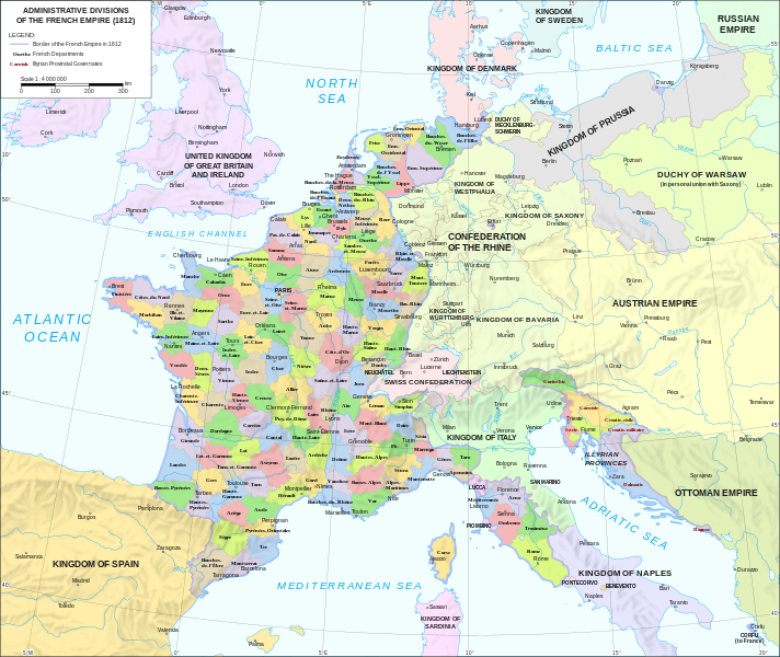
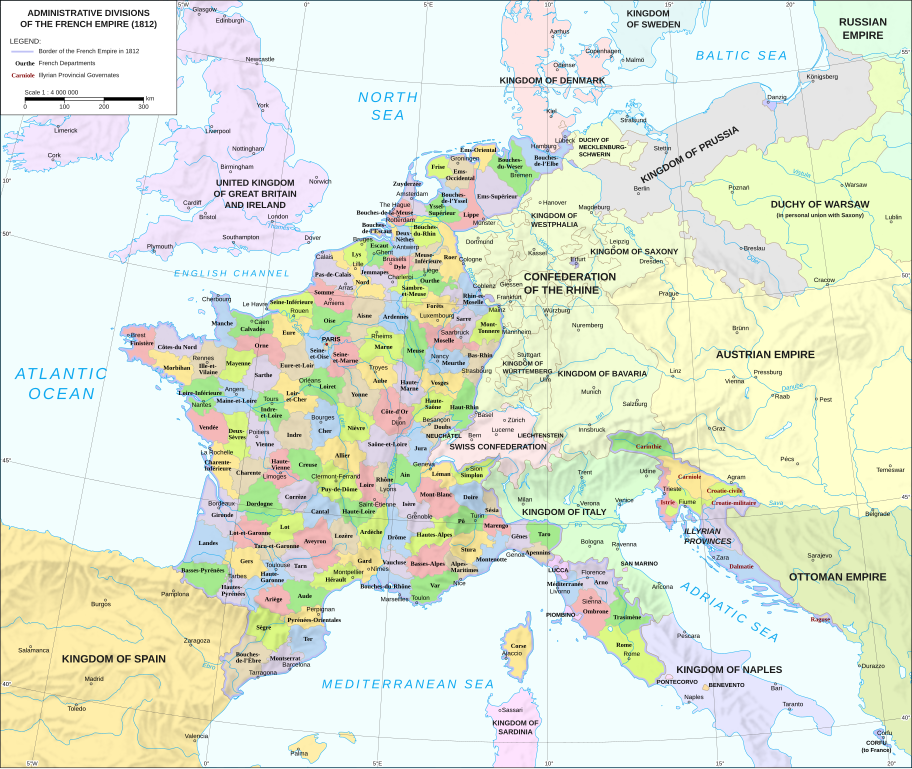
Català: Divisions administratives del Primer Imperi Francès el 1812
English: Administrative divisions of the First French Empire in 1812 |
| Date | |
| Source |
|
| Auteur | Andrein |
| Autres versions |
Other related versions:[]
|


|
Ce fichier SVG contient du texte encapsulé pouvant facilement être traduit dans votre langue en utilisant n'importe quel éditeur de fichier SVG ou de texte, ou par l'outil de traduction de fichiers SVG. Pour plus d'informations, voir : A propos de la traduction des fichiers SVG. |
Ce fichier a été traduit en utilisant des balises SVG <switch>. Toutes les traductions sont stockées dans le même fichier ! En savoir plus.
Sur la plupart des versions linguistiques de Wikipédia, vous pouvez inclure le fichier normalement (sans le paramètre Pour traduire le texte dans votre langue, vous pouvez utiliser l'outil de traduction de fichiers SVG. Sinon, vous pouvez télécharger le fichier sur votre ordinateur, y ajouter vos traductions avec tout logiciel adapté dont vous avez l'habitude, puis le téléverser à nouveau sous le même nom. L'Atelier graphique peut vous aider si vous avez des doutes sur la procédure à suivre. |
Conditions d’utilisation
- Vous êtes libre :
- de partager – de copier, distribuer et transmettre cette œuvre
- d’adapter – de modifier cette œuvre
- Sous les conditions suivantes :
- paternité – Vous devez donner les informations appropriées concernant l'auteur, fournir un lien vers la licence et indiquer si des modifications ont été faites. Vous pouvez faire cela par tout moyen raisonnable, mais en aucune façon suggérant que l’auteur vous soutient ou approuve l’utilisation que vous en faites.
- partage à l’identique – Si vous modifiez, transformez, ou vous basez sur cette œuvre, vous devez distribuer votre contribution sous la même licence ou une licence compatible avec celle de l’original.
Historique du fichier
Cliquer sur une date et heure pour voir le fichier tel qu'il était à ce moment-là.
| Date et heure | Vignette | Dimensions | Utilisateur | Commentaire | |
|---|---|---|---|---|---|
| actuel | 9 février 2024 à 14:33 | | 2 052 × 1 728 (3,86 Mio) | Manlleus | added catalan language |
| 21 mai 2021 à 19:10 |  | 2 052 × 1 728 (3,55 Mio) | Andrei Stroe | File uploaded using svgtranslate tool (https://svgtranslate.toolforge.org/). Added translation for ro. | |
| 30 août 2020 à 14:32 |  | 2 052 × 1 728 (3,24 Mio) | Jfblanc | File uploaded using svgtranslate tool (https://svgtranslate.toolforge.org/). Added translation for oc. | |
| 1 mars 2018 à 12:37 |  | 2 052 × 1 728 (2,83 Mio) | Imperator Honorius | Formatting Fix | |
| 1 mars 2018 à 12:29 |  | 2 052 × 1 728 (2,83 Mio) | Imperator Honorius | Formatting and missing Anglicization (Gand to Ghent) | |
| 1 mars 2018 à 12:17 |  | 2 052 × 1 728 (2,83 Mio) | Imperator Honorius | Spelling and typos; more Anglicised (and up to date) city names. | |
| 20 juillet 2015 à 21:41 |  | 2 052 × 1 728 (2,82 Mio) | ArdadN | spelling | |
| 20 juillet 2015 à 19:11 |  | 2 052 × 1 728 (2,81 Mio) | ArdadN | 1 | |
| 20 juillet 2015 à 19:05 |  | 2 052 × 1 728 (2,81 Mio) | ArdadN | font size | |
| 20 juillet 2015 à 18:06 |  | 2 052 × 1 728 (2,81 Mio) | ArdadN | 1 |
Utilisation du fichier
Les 5 pages suivantes utilisent ce fichier :
Usage global du fichier
Les autres wikis suivants utilisent ce fichier :
- Utilisation sur af.wikipedia.org
- Utilisation sur ar.wikipedia.org
- Utilisation sur ca.wikipedia.org
- Utilisation sur en.wikipedia.org
- History of the Netherlands
- 1810s
- Departments of France
- 130 departments of the First French Empire
- Illyrian Provinces
- Kingdom of Italy (Napoleonic)
- Portal:Maps/Maps/Political
- Portal:Maps/Maps/Political/14
- First French Empire
- Bouches-del'Èbre
- Department of Segre
- Left Bank of the Rhine
- Portal:Maps
- User:Dakaysaa/sandbox
- User:Falcaorib/France
- Utilisation sur et.wikipedia.org
- Utilisation sur hr.wikipedia.org
- Utilisation sur it.wikipedia.org
- Utilisation sur ka.wikipedia.org
- Utilisation sur km.wikipedia.org
- Utilisation sur no.wikipedia.org
- Utilisation sur pl.wikipedia.org
- Utilisation sur pnb.wikipedia.org
- Utilisation sur pt.wikipedia.org
- Utilisation sur ru.wikipedia.org
- Utilisation sur tr.wikipedia.org
- Utilisation sur ur.wikipedia.org
- Utilisation sur vi.wikipedia.org